An interactive field survey · West Manggarai, Flores
When Growth Meets Inequality
Indonesia built a 25 kilometre road through five villages in western Flores, and told the public it cost nothing in land. This is a map of what it cost the people who live along it.
About this projectIntroduction
Labuan Bajo
A fishing town on the western tip of Flores and the gateway to Komodo National Park. In 2018 the government named it one of Indonesia's five super priority tourism destinations, and the money followed.
Residents had already been saying the same thing for years. The town was being built for visitors before it was built for the people living in it.
National Tourism Strategic Area, designated a super priority destination in 2018.
Before the road
Getting out was the problem
South of the town there was no reliable way through. In the wet season the track turned to deep mud. Moving a harvest or a load of livestock to the city was a journey of two or three days.
The alternative was the sea.
Nanganae residents: what now takes thirty to sixty minutes once took two or three days.
Before the road
Gambling with your life
This is Selat Molo, the narrow gap between mainland Flores and Rinca. Water masses meet here from north and south, and the current runs like a river in a hurry. It is known for whirlpools.
Boats left from Dermaga Lenteng, below Soknar, in open deck wooden fishing boats. The skipper read the tide before committing to the gap.
Every trip to a hospital, a market or a school began with that judgement.
Soknar residents: two and a half hours by boat to Labuan Bajo, the only alternative to the land route.
Before the road
Three hours, or all day
The sail itself is not long. Thirteen nautical miles from Dermaga Lenteng to the Labuan Bajo wharf, two and a half to three hours in a wooden boat.
What took the day was the strait. When the tide ran hard, boats pulled in behind the nearest island and waited, sometimes for hours, until it was safe to cross. Leave at dawn, arrive at dusk. Not because the distance was great, but because the sea decided when you could go.
Residents describe leaving in the morning and arriving in the afternoon. The sailing time and the character of the strait come from published accounts of the route.
Introduction
What was built
A national strategic project, built by the Ministry of Public Works to carry heads of state to a leaders' retreat at the Golo Mori Special Economic Zone.
It was not first drawn for that summit. Golo Mori was to have hosted the G20 in 2022. When that meeting moved away from Labuan Bajo the road did not stop, it was pointed at the next event instead. The corridor was following a calendar, not a population.
The contract allowed 222 days. Handover came on 10 March 2023, sixty days before the summit opened. That deadline shaped everything that follows.
Contract signed 21 April 2022, work from 22 April, handover 10 March 2023. The G20 origin is stated by the Ministry and confirmed by Nanganae residents.
The official record
Not a single cent
We took a social and cultural approach, so there was no compensation, not a single cent. Directorate General of Highways, on the project's land acquisition
The public record states that residents gave their land willingly, and dismantled and moved their own houses to make way.
Ministry of Public Works: the road was built without land acquisition cost.
The corridor
Five villages
The survey went to five settlements along the road, from Nanganae in the north to Golo Mori at the far end, to ask what willingly meant in each of them.
These five are not the whole corridor. Published reporting also places compensation protests in Nalis, and flooded rice fields in Mberata and Nalis. Neither village was visited.
Sixteen residents interviewed across the five villages, 8 to 10 April 2026.
Method
How this was measured
A road can be wanted and still be unjustly built. To hold both at once, the survey tested the corridor against five dimensions of justice rather than asking whether people liked it.
The villages · Nanganae
The first village
Three kilometres south of the Labuan Bajo end, the road enters its first settlement. The agency's own drawings label this segment simply: permukiman, housing.
Nanganae already had a road. This stretch is part of the 6.41 km the project upgraded rather than cut new, and that fact turns out to matter later, when the money is handed out.
A bridge of sixty metres carries the road across the river here, the longest on the whole corridor. What happened next in Nanganae is the clearest test of whether local knowledge counted as knowledge.
Segment 1 of 5. Nanganae bridge at km 2.694, 60 m, the longest of the four.
The villages · Nanganae
The water finds the fields
The farmers said it before it was built. Road drainage must not be joined to the irrigation. It was.
The carriageway was raised, and the houses beside it were not. Several now sit below the level of the road, so the rains and whatever the surface sheds run down into the yards and into the paddy channels the rice depends on.
Epistemic: technical knowledge offered and ignored. Restorative: residents built their own embankments, nothing was repaired.
The villages · Nanganae
What was drawn, what was there
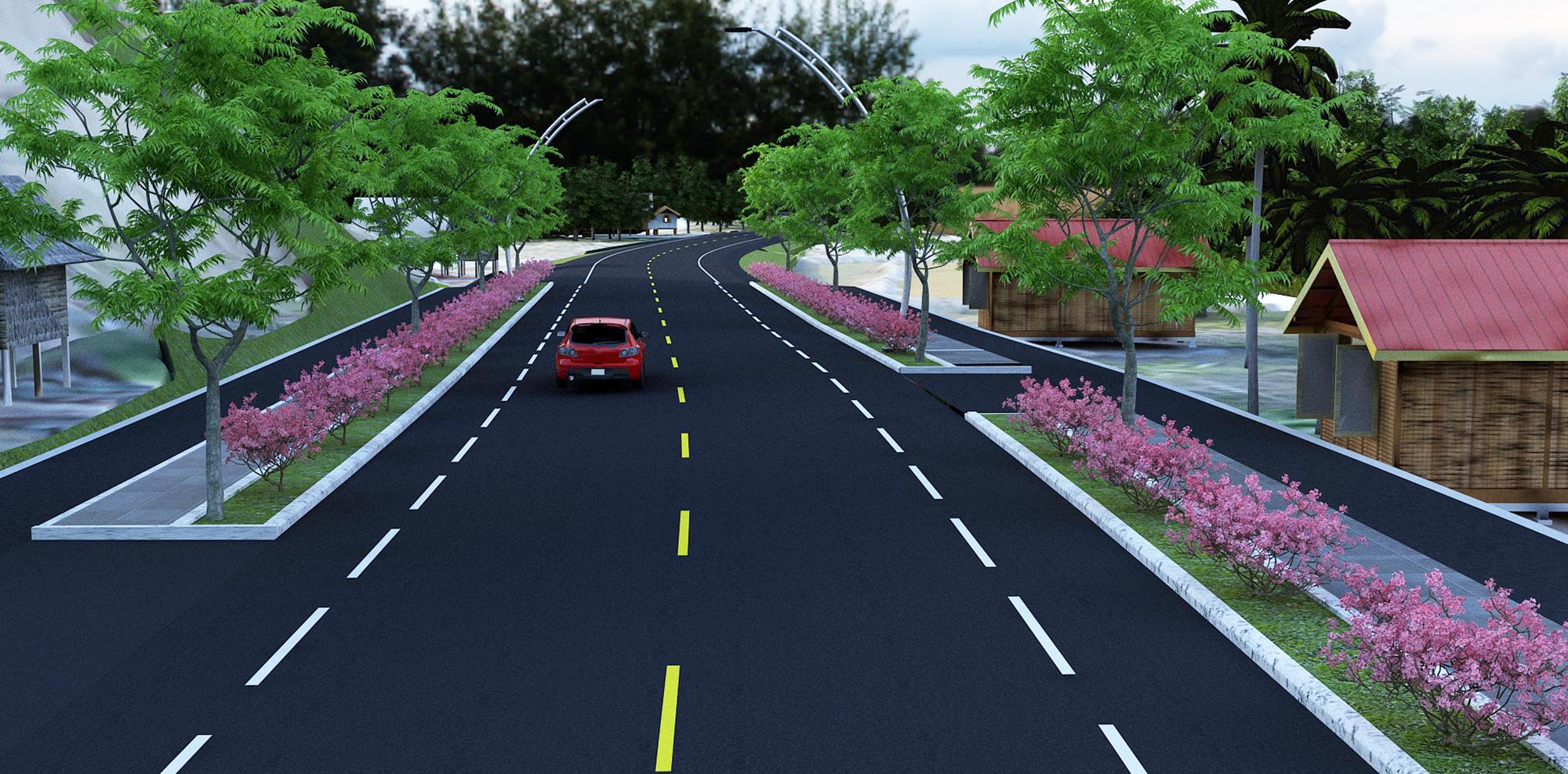
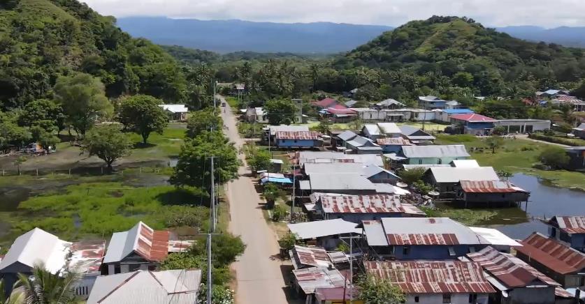
The design for this segment shows a divided boulevard with planted medians and footways. The agency's own aerial of the same place, taken before the works, shows houses packed tight along a dirt track with standing water at their backs.
Both pictures are true. The distance between them is where the flooding lives.
Design rendering and pre construction aerial, both from the implementing agency.
The villages · Nanganae
The tree in the alignment
A large tree stood exactly where the road was drawn to go, and it was not an ordinary tree. The community held it sacred.
The tree was felled. What the agency did not do was fell it first and explain afterwards. It went to the customary elders, and a ceremony was held before the saw, permission asked. On a corridor where consent was so often assumed, this is the one place the record shows it being sought.
Epistemic: customary authority recognised, permission sought, the tree removed anyway. No survey photograph exists. The tree still stands in 2016 street level imagery: view the 2016 street imagery.
The villages · Cumbi
They asked for it
The state first drew the road around the outside of Cumbi, precisely to avoid taking houses. The residents pushed back, in meetings and then in the street. Run it through the village, they said, where the access would be worth something to us. The district head came in person to tell them there would be no compensation if it did. They insisted, and they won.
This is the part that complicates the story. The community did influence the decision.
It complicates it only so far. At the outset the plan was not shown to the village at all, only to its leaders.
Deliberative: real influence over the route, won partly through public demonstration. Procedural: the consequence was stated plainly. Who got to hear the plan first was not.
The villages · Cumbi
What willingly looked like
They were promised a road that would wind around the houses. What arrived was drawn straight. Homes came down, dismantled by their owners under a three day order.
The choice put to them was not really a choice. Officials arrived with armed police and set out two options: accept the road through the middle of the village with no compensation, or have it built outside the village altogether. Residents signed a statement agreeing to no payment.
They are still paying property tax on the land the road took. It was never removed from the assessment.
Deliberative: agreement obtained under intimidation. Distributive: taxed on land they no longer hold.
The villages · Kenari
Where the road works
Kenari is the counterweight. Support here is close to total. A mechanic moved his workshop to the new frontage and watched his takings climb as traffic he had never seen before rolled past.
Land was cut here too, with no payment. A public hearing was held and residents were told plainly that their land was needed and nothing would be paid for it. They agreed, because they needed the road. The hearing did not invite everyone whose land it was about.
The design for this stretch is the most elaborate on the corridor: a roundabout, erosion matting on the cut slopes, flame trees and NTT cherry every fifteen to twenty metres, teak every seven. Further north, residents whose land the road had taken said the teak planted along their frontage was not something they wanted.
Distributive: genuine gains. Deliberative: the hearing reached only the people whose land was already marked. Land given from need, not from agreement over terms. Landscaping specification from the agency briefing.
The villages · Soknar
The well under the road
Soknar had been the most cut off of all, and welcomed the road. Residents now run their own pickup service to the city.
Then the route was changed, and houses previously marked safe were suddenly in the way. The residents it newly affected were not told. One who protested was outvoted by neighbours who wanted the road. Under the new asphalt lies the well that was the village's main source of clean water.
Nobody mentioned that the carriageway would sit higher than the houses either. Dozens of homes now flood. Complaints went to the village office and stopped there.
Procedural: the route changed and the elevation changed, neither was communicated. Restorative: relocation money was paid, but residents could not establish how much, from where, or on what basis.
The villages · Soknar and Golo Mori
The service nobody provided
A road with nothing running on it is only half a road. No public transport was ever put on this one, so two villages built their own.
Residents pooled their own cars into a communal service. It carries agricultural produce to Labuan Bajo, and it is how people reach a clinic. The vehicles, the fuel and the organising all come from the villages.
Distributive: the state funded the corridor and left the service to the people it runs past.
The institutions
Four questions, six offices
Six state bodies planned, built, registered and benefited from this corridor. Put the same questions to each and a pattern appears, clearest of all on compensation, where almost nobody claims responsibility.
One answer stands out. Asked whether consultation was adequate, the ministry's regional infrastructure arm replied that public participation in infrastructure planning is not regulated at all. There is no rule that anyone had to follow.
Select any answer in the grid to read it in full.
The villages · Golo Mori
They cleared the way themselves
Golo Mori is where the road was always going. Before it, the village could be reached only by sea. The zone operator puts it flatly: without the road, Golo Mori would never have developed at all.
The road ends at the entrance of the Special Economic Zone, the summit venue. Work did follow, and residents took it. The jobs are in security and cleaning, with a hospitality training programme run with local schools.
Distributive: the road serves the zone it was built for, and the zone employs the village at the bottom of its wage scale.
The villages · Golo Mori
The pipes across the road
Golo Mori has no piped supply, so residents laid their own water lines. The road was built over them with no duct to carry them underneath.
Every vehicle that passes presses on the casing. The pipes split, and the village repairs them again, roughly once a month, at their own cost.
Epistemic: an existing village system was not designed for.
After the road
What came up the road
A finished road is an opening, and what came through it was not only buses. Quarrying spread along the corridor. The riverbed dropped, and water stopped reaching the rice fields.
Residents who protested that damage were arrested and charged by police with disrupting the companies' operations.
In the Wae Wuul nature reserve, traffic on the new surface has killed two Komodo dragons.
And the land itself began to move. Buying along the corridor started before construction did, which means somebody knew the alignment early. Prices rose steeply, ownership passed from local families to investors, and at Puncak Golo Mori beach residents now pay to enter ground they used to walk onto.
Distributive: long term gains accrue to landowners who are no longer local. Deliberative: objection carried a criminal penalty. Community advocate, land office and district public works, April 2026.
Findings
Not one experience, five
Reading the corridor village by village shows what a single verdict would hide. Kenari and Golo Mori wanted the road and largely gained from it. Cumbi and Soknar carried the cost of how it was delivered.
These are village level readings and they do not add up to the corridor level verdict. Across the whole road the research finds deliberative and distributive justice unmet, and procedural, epistemic and restorative justice only partly met. Some cells here are blank because the survey produced no evidence either way, and a gap is not a finding.
Select any cell for the evidence, the reason for the reading, and the documentation.
In closing
The road is real, and it is wanted. The process that produced it was not just. Both statements rest on the same testimony, and this survey holds them together rather than choosing between them.
What the record calls a social and cultural approach, the villages experienced as a decision already made. That gap, not the asphalt, is the finding.
Method, credits and contact